Play all audios:
Inscribed on the UNESCO World Heritage list, the sub-Antarctic Crozet archipelago is located in a region facing significant environmental changes impacting a poorly known marine
biodiversity. Underwater imagery constitutes a valuable non-invasive approach for gathering ecological data and improving our knowledge of ecosystems’ vulnerability. We here compiled two
datasets, encompassing 17 video-imagery surveys of Crozet nearshore environments conducted in 2021 and 2022 at two sites of Ile de la Possession: Baie du Marin and Crique du Sphinx. Faunal
abundance and algal cover data related to each survey are also provided. A total of 755 images were analysed, comprising 52 faunal and 14 algal taxa identified in 2021, as well as 45 faunal
and 14 algal taxa identified in 2022. Video-transects were performed in shallow waters by scuba divers using a GoPro®HERO7 multiple camera set-up, and in deeper waters using a remotely
operated vehicle. These data provide a first baseline for biodiversity and ecosystem studies, and for monitoring the long-term dynamics of Crozet benthic habitats facing natural and
anthropogenic disturbances.
Atmospheric temperature records have clearly indicated a long-term warming trend in the Southern Ocean over the twentieth and beginning of the twenty-first centuries1,2,3,4,5,6, including
the French sub-Antarctic islands such as the Crozet archipelago. At Crozet, air temperature increase has been estimated to be +1.2 °C/100 years5. This global warming is coupled with
underlying phenomena, such as significant seawater temperature increase7,8, ocean acidification9, extreme climatic events and pronounced seasonality10,11. These environmental changes are
expected to induce substantial alterations of the structure and functioning of sub-Antarctic marine ecosystems12, as already observed at Prince Edward Islands13. A good knowledge of these
marine environments is a prerequisite to understand the impacts of global change and to establish sustainable management policies.
Coastal habitats are highly productive areas inhabited by dense marine vegetation and a diverse array of benthic organisms14. They exhibit important variations of structural complexity,
substrate composition, and environmental conditions, leading to a large diversity of ecological niches that influence the distribution, composition, and structure of benthic
communities15,16,17. Faunal12,18,19,20,21,22 and algal12,23 diversities are unique in sub-Antarctic nearshore marine ecosystems. However, the slow growth rate of benthic organisms makes them
particularly at risk with regards to environmental disturbances24,25,26. As also reported along the Antarctic Peninsula27, Lelièvre et al.12 highlighted that faunal communities of Ile de la
Possession (Crozet archipelago) displayed functional characteristics indicating a potential vulnerability to diversity loss due to current and future environmental changes. These findings
emphasize the importance to conduct diversity studies to track the long-term evolution of these communities and evaluate their resilience to environmental changes.
Conducting benthic studies in these isolated territories is challenging considering extreme environmental conditions (e.g., sea and meteorological conditions), logistics issues and financial
limitations. Whereas a thorough knowledge of the biodiversity and ecological functioning of these polar ecosystems is necessary for their protection and conservation, the complex interplay
between these multiple limitations hampers the acquisition of ecological data. Imaging technologies stand as powerful and suitable approaches to enhance our understanding of marine
habitats12,18,28,29,30. Ethical considerations underscore the value of underwater video-monitoring methods as they provide a non-invasive means to gather highly informative data29. By
covering large surfaces and providing repeatable measurements29,30, video-imagery can give an extended overview of habitats and benthic communities, and constitutes an important tool for
environment monitoring and evaluation of the potential impacts of climate change and anthropogenic activities on sub-Antarctic ecosystems12.
Although the maritime domain surrounding Crozet Islands is managed as a nature reserve and was classified on the UNESCO World Heritage list in 2019, datasets on benthic ecosystems are still
limited12. In the present data paper, we describe video-imagery datasets acquired at Crozet in 2021 and 2022 as an outcome of project No. 2021-0882 “Nearshore Cable Inspection and
Environmental Survey at IMS Hydroacoustic Station HA04 Crozet, France” conducted by the French Southern and Antarctic Territories (TAAF) in the frame of the Comprehensive Nuclear-Test-Ban
Treaty Organization (CTBTO)31 partnership, and to the French Polar Institute project #1044 Proteker. Imagery datasets were collected by using an image acquisition set-up in shallow waters
(from 0 to 20 m depth) and a remotely operated vehicle (ROV) in deeper waters (from 20 to 60 m depth). The MEDUSA (Marine benthic Ecological Data from Underwater imagery Surveys of
sub-Antarctic Crozet environments) dataset includes (i) 17 video-transects recorded at two sites along the eastern coast of Ile de la Possession, Baie du Marin and Crique du Sphinx; as well
as (ii) biological data on benthic communities (faunal abundance and algal surface cover) obtained from the analysis of the video-transect imagery. To our knowledge, these still images and
video-datasets are the very first records of benthic ecosystems conducted at the Crozet archipelago, offering to users a wide range of imaging processing and analysis possibilities. The
MEDUSA dataset brings novel and valuable information to our understanding of the structure and functioning of Crozet benthic nearshore marine ecosystems, and opens new research avenues for
sub-Antarctic ecological studies in general.
Discovered in 1772 during the expedition of the French explorer Marc Joseph Marion-Dufresne, the Crozet archipelago (45°48′S – 46°26′S; 50°14′E – 52°15′E) – located at 2,400 km north of the
Antarctic Continent and 2,400 km southeast of South Africa – is composed of five small volcanic islands. These islands include, from west to east: Île aux Cochons, Îlots des Apôtres, Île des
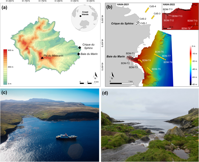
Pingouins, and the two largest islands of the archipelago, Île de la Possession and Île de l’Est32. Ile de la Possession (46°25′S; 51°45′E; Fig. 1a) – approximately 18 km wide by 15 km
long, with a total surface area of ~156 km2 – is the emerged part of a stratovolcano reaching an elevation of 934 m above sea level (a.s.l.) (Pic du Mascarin). Data presented here were
acquired at two sites located on the eastern coast of Ile de la Possession, at Baie du Marin and Crique du Sphinx (Fig. 1b).
(a) Topographic map of Ile de la Possession (Crozet archipelago, Southern Ocean) with the location of both study sites; (b) Overview of the video transect surveys’ sampling design conducted
at Baie du Marin and Crique du Sphinx in 2021 and 2022. More details on the HA04-Crozet-2022 imagery sampling design are provided in Lelièvre et al.12. Bathymetry product of CTBTO-IPEV-TAAF
cruise MD202/CTBTO-CRO R/V Marion Dufresne, Mesuris survey (2016); Photographs of (c) Baie du Marin. Photo courtesy of Comprehensive Nuclear-Test-Ban Treaty Organization; and (d) Crique du
Sphinx. Photo courtesy of Proteker project.
Baie du Marin (BDM; 46°25′54″S; 51°52′11″E; Fig. 1c) is a narrow inlet of c. 500 m length and 200 m width in its shallowest part (