Play all audios:
ABSTRACT The Amazon basin is experiencing severe droughts that are expected to worsen with climate change. Riverine communities are especially vulnerable to these extreme events. This study
investigates the experiences of Brazilian Amazonian communities during droughts occurring from 2000-2020. We assess the distribution of settlements at risk of prolonged isolation during
extreme low-water periods, along with impacts reported in digital news outlets. Using historic time series of river levels from 90 gauges, we look at how long droughts lasted in regions with
reported impacts. Results indicate that the droughts in 2005, 2010, and 2016 were the most severe, with over an additional month of low water levels in those years. Such drought events
routinely disrupt inland water transport and isolate local populations, limiting access to essential goods (food, fuel, medicine) and basic services (healthcare, education). Given this new
reality, Amazon countries must develop long-term strategies for mitigation, adaptation, and disaster response. SIMILAR CONTENT BEING VIEWED BY OTHERS RIVERINE COMMUNITIES IN THE CENTRAL
AMAZON ARE LARGELY SUBJECT TO EROSION AND SEDIMENTATION RISK Article Open access 20 February 2025 DIAGNOSING CHALLENGES AND SETTING PRIORITIES FOR SUSTAINABLE WATER RESOURCE MANAGEMENT UNDER
CLIMATE CHANGE Article Open access 17 January 2022 FLOOD FATALITIES AND DISPLACEMENT INFLUENCE HUMAN MIGRATION IN FLOODPLAINS OF DEVELOPING COUNTRIES Article Open access 24 April 2025
INTRODUCTION The Amazon River basin covers an area of around 7 million km2, encompassing a vast tropical rainforest and freshwater ecosystems that extend over 14–29% of its total area1. The
Pan-Amazon region spans nine countries, including the largest expanse of remaining tropical rainforests and all major tributaries of the Amazon River. The area is home to approximately 47
million people, including Indigenous and non-Indigenous populations, as well as urban and rural dwellers2. Most Amazonians rely on navigation as part of their daily lives since rivers are
the region’s primary means of medium- to long-distance transportation3. Yet today this vast river system and the surrounding floodplains and forests are under immense pressure due to the
compounding effects of climate change, deforestation, and fire4,5. Climate projections suggest that the Amazon will experience increasingly drier conditions and more frequent extreme events,
including droughts and floods6,7,8. Indeed, the hydroclimatic record already shows an intensification of the hydrological cycle, with recent droughts (as in 2005, 2010, 2015-2016, and 2023)
occurring more frequently than in previous decades3,9,10. These drought years are associated with anomalously low rainfall, which translates to low-water level events that can have
cascading impacts on local populations and the freshwater ecosystems they depend upon. The 2023 drought proved to be an unprecedented example of these extreme events—with abrupt decreases in
water levels and abnormally high air temperatures triggering fish kills, river dolphin mortality, disrupted navigation, isolation of rural dwellers, and massive wildfires in the central
Amazon10,11,12,13. Given its dependence on predictable water levels, inland water transport (i.e., by river boats and vessels) is substantially more sensitive to droughts than other modes of
transport14. Hydrological droughts – defined as sustained periods of below-normal water levels15,16—can therefore impact inland navigation by forcing reduced vessel speed and course changes
to avoid obstacles (e.g., sand bars and rocks); limiting access to ports and moorings; or requiring reduced vessel loads17. In the context of the Amazon, extreme droughts can also
completely halt navigation, disproportionately impacting rural communities. The consequences of these extreme events include the total isolation of villages for weeks to months3,18, leading
to shortages of food and medical supplies19,20,21, as well as limited access to health services and education facilities22. Severe droughts may also reduce protein sources for local
families23,24, given degraded water quality and restricted access to fishing sites during these extreme events. Few studies have examined the direct and indirect effects of severe droughts
on local Amazonian people through disruptions to navigation. Although some studies have described the various impacts of droughts on riverine communities (known as “ribeirinhos” in
Portuguese), these were only able to address a small number of cases20,25,26,27. Others have focused on the hydrological impacts of drought events, highlighting the critical importance of
inland water transport for local people3,19,21. To the best of our knowledge, there has been no systematic, spatially explicit analysis of these impacts at the scale of the Amazon basin.
Large-scale studies on cross-sectoral impacts of droughts have been constrained by data availability28,29. In response, several drought observatory initiatives have emerged30,31 and research
groups have begun exploring media content (e.g., newspaper articles) as a source of information for qualitative assessments of widespread cross-sectoral drought impacts28,29,32,33,34,35.
Here we assess the impacts of droughts occurring from 2000 to 2020 on the local populations of the Brazilian part of the Amazon basin, focusing on impacts related to limited accessibility
and mobility in the region. To do so, we first assessed the extent to which communities rely on rivers and wetlands for transport. We then analysed the impacts of past droughts reported in
media outlets, comparing them with the available academic literature and exploring the hydrological conditions that accompanied those events. RESULTS AND DISCUSSION PROXIMITY TO RIVERS AND
ROADS The Brazilian part of the Amazon basin encompasses 3671 non-Indigenous localities, which can be subdivided into 3259 remote rural settlements, 251 cities (including 5 state capitals),
and 161 villages36. In addition, there are 2521 Indigenous villages (“aldeias”)37 (Supplementary Fig. 1). To identify the non-Indigenous localities and Indigenous villages most prone to
isolation during droughts, we quantified and compared the nearest straight-line distance from these settlements to major water bodies and roads (see Supplementary Table 1 for data sources).
_Non-Indigenous localities_: Our results show that 89% of non-Indigenous localities (_n_ = 3259) are up to 5 km away from the nearest major water body during the high-water season, but this
number drops to 84% during the low-water season. About 77% of all localities (_n_ = 2841) are situated <1 km away from major water bodies during the high-water season, compared with 73.6%
in the low-water season. The average straight distance is 1.7 km (high water) and 2.6 km (low water), with median values of 0.4 and 0.5 km, respectively. In contrast, 48.5% of localities
(_n_ = 1779) are <5 km away from the nearest road (independent of road conditions), while the rest are located 5–200 km away (average straight-line distance = 18.6 km; median = 5.9 km).
The localities closest to roads (<1 km away) represent only 38.4% (_n_ = 1411) of the total. In sum, 2222 localities (60.5%) are closer to major water bodies than to roads during high
water, compared with 2185 (59.5%) during low (Supplementary Note 1, Supplementary Tables 2–7). To identify the geographical distribution of non-Indigenous localities prone to isolation
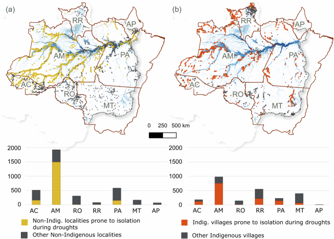
during droughts, we selected those that are ≤5 km away from major water bodies (high-water season) and >5 km away from roads (_n_ = 1850) (Fig. 1a). Most (_n_ = 1495, 80.8%) are in the
state of Amazonas, followed by 160 (8.6%) in Acre, 155 (8.4%) in Pará, 13 (0.7%) in Roraima, 11 (0.6%) in Rondônia, 10 (0.5%) in Amapá, and 6 (0.3%) in Mato Grosso. Assuming that an average
human pace on forest trails is approximately 5 km per hour38, settlers from these localities could face at least 1 h on foot (straight line distance) to reach the nearest roads. Even then,
they might face constraints associated with the availability of vehicles, poor road conditions (even worse during the rainy season), and lack of connectivity. By relying on rivers and
wetlands as paths for transport, they can access nearby communities, urban areas, and resources during average conditions. However, they might be more vulnerable during extreme droughts,
when water levels fall and extensive floodable areas go dry. _Indigenous villages_: Our results show that 92.2% of Indigenous villages (_n_ = 2325) are <5 km away from the nearest major
water body during the high-water season, dropping to 82.8% during the low-water season. An estimated 1971 (78.2% of total) of these are <1 km away from water bodies during high water,
compared with 1736 (68.9%) during low water. The average shortest path is 1.3 km (high water) and 3.0 km (low water), with median values of 0.4 and 0.5 km, respectively. In contrast, just
44.8% of Indigenous villages (_n_ = 1131) are located <5 km away from the nearest road (independent of road conditions), with the rest located 5–183 km away (average straight-line
distance = 20.5 km; median = 7.9 km). Only one-third (30.1%, _n_ = 760) of Indigenous villages are close to roads (<1 km away) (Supplementary Note 1, Supplementary Tables 8–13). Our
results indicate that 1671 (66.3%) Indigenous villages are closer to water bodies than to roads during high water, compared to 1584 (62.8%) during low water. Selecting Indigenous villages ≤5
km away from major water bodies (high-water season) and >5 km away from roads (_n_ = 1359), we find that 755 (55.6%) are in the state of Amazonas, 225 (16.6%) are in Roraima, 152 (11.2%)
in Pará, 125 (9.2%) in Acre, 16 (1.2%) in Rondônia, 13 (1.0%) in Amapá, and 73 (5.4%) in Mato Grosso (Fig. 1b). SPATIAL AND TEMPORAL PERSPECTIVES ON DROUGHTS To evaluate the exposure of
Amazonian communities to past extreme drought events, we collected and analysed digital news articles reporting the impacts of droughts from 2000 to 2020. We identified a total of 70 news
articles, from which we extracted 142 statements reporting the effects of droughts and/or impacts on local populations. Of these, 117 statements reported some impact of droughts on the lives
of local populations via effects on economic activities, whereas 26 only reported effects on water levels and/or the environment, such as increased fire occurrence or erosion along
riverbanks due to low water levels. After accounting for each location mentioned in the statements (one statement could mention multiple locations), we documented 224 entries. Each statement
could also include information about more than one category of impact (see Supplementary Data 1). The years 2005, 2010, and 2016 were noteworthy in terms of the number of media articles
reporting the impacts of droughts according to our analysis (Fig. 2). These years are recognised in the literature as the most affected by droughts since the beginning of the 21st century,
with the effects reported in 2016 beginning with the drought in 201539,40,41,42. Nevertheless, localised impacts of drier conditions were also registered via news outlets in other years
(e.g., 2009 and 2019). Considering only media articles that mentioned specific months (_n_ = 69), October was the month with the highest number of news pieces reporting droughts (_n_ = 19),
followed by September (_n_ = 15) and August (_n_ = 11). In terms of temporal distribution, the impacts of the droughts in 2005 and 2010 were mostly reported in the months of September,
October, and November, while the 2015–2016 drought was more widespread, with news articles pointing to impacts across several months (Fig. 2). Analysing the spatial distribution of these
news articles, 2005 and 2010—two years marked by extreme droughts across the Amazon—registered substantial impacts on local populations, particularly in the central and western Brazilian
Amazon. In 2005, we found news documenting impacts on rural areas of the Purus, and lower Negro River basins as well as southern tributaries of the Solimões River near the border between
Brazil and Colombia. Most of this area was in Amazonas state, which has the highest number of localities and villages prone to isolation during droughts (Fig. 3). Amazonas is the largest
state in the basin and contains the most pristine portions of the Amazon rainforest. The sub-basins reported in the news also covered the entire state of Acre. Accounts indicate that the
drought of 2010 might have affected over half of the Brazilian portion of the Amazon basin, covering the Madeira, Purus, Juruá, and Negro River basins, as well as the Solimões tributaries
near the border between Amazonas state and Peru (Fig. 3). It is also the year with the largest number of collected news articles (Fig. 2). Our results also corroborate previous studies
showing that 2015–2016 was a particularly strong drought39. Collected news accounts showed effects across the Amazon basin, including the Madeira, Xingu, Juruá, and Purus River basins. News
collected from 2019 pointed to impacts in the northern Madeira and western Xingu River basins, while in 2020 impacts were mostly felt in the Negro and Juruá River basins, as well as some
Solimões tributaries (Fig. 3). Notably, the Negro River basin made headlines in nearly half of the years from 2000 to 2020. HYDROLOGICAL RECORDS To assess the hydrological conditions
associated with reported drought impacts on Amazonian communities, we analysed data from 90 river gauges distributed across the affected area, as reported in media articles (Supplementary
Note 2, Supplementary Fig. 2, Supplementary Data 2). We defined the hydrological year as beginning on December 1 of the previous year and ending on November 30 of the subsequent year (e.g.,
the hydrological year of 2016 is defined as starting in Dec 1, 2015)43. We adopted the long-term 80th percentile of the water level duration curve (P80) as the cutoff for low-water levels,
counting the number of days in which water levels fall below this reference historical level in a given hydrological year. Levels below the reference represent the driest conditions
experienced at a given river gauging station over the historical record. Our results show that 2005, 2010, and 2016 saw the longest low-water periods at the analysed stations for the
2000–2021 interval (Fig. 4), coinciding with the highest numbers of media articles on local impacts. In these extreme drought years, the period with levels below P80 was ~36.8 days longer
than the median for the whole historical time series, with some years exceeding 100 days below long-term P80 (median values for 2005 = 101 days; 2010 = 119.5 days; 2016 = 118 days). In terms
of spatial distribution, a smaller dispersion around the median indicates more homogenous behaviour across regions. By that measure, 2005 and 2010 were relatively uniform events with more
river gauging stations showing longer low-water periods. The years with the largest dispersion in terms of number of days below the reference were 2006 (StDev = 37.8), 2011 (StDev = 43.1),
2015 (StDev = 36.2), 2017 (StDev = 36.2), 2020 (StDev = 36.5), and 2021 (StDev = 42.7). The large dispersion values observed in the hydrological years of 2006, 2011, and 2015 indicate the
varied spatial response to the transition from/to the extreme hydrological droughts observed in 2005, 2010, and 2016, respectively (Supplementary Data 3). A key finding of this study is that
recent hydrological droughts have not only caused exceptional low-water anomalies across the Amazon basin but also dramatically increased the duration of the low-water period. The river
gauge data shows over one additional month of low water levels during these severe droughts (Fig. 4), which has profound implications for aquatic fauna, freshwater ecosystems, and the
riverine communities that depend on them. Today, riverine communities are being exposed to impaired conditions, with limited access to resources and services, both more frequently (i.e.,
recurrent events) and for much longer (i.e., during a given event) than in the past. River flows in the Amazon basin are strongly influenced by El Niño and La Niña events44. However, the
warming of the North Atlantic Ocean has also been associated with longer dry periods in the basin. For instance, the drought of 2005 was associated with a warmer subtropical North Atlantic
Ocean45, while the 2010 drought was connected to the combined effect of an El Niño, intensified by a subsequent warming of the Tropical North Atlantic3. The 2015–2016 hydrological drought,
on the other hand, was mostly associated with an El Niño event, which produced a strong and widely distributed land surface warming during the months of October, November, and December of
201539. Some of these drivers are also implicated in the extreme drought of 2023, which resulted in some of the lowest river levels on record for the central Amazon10,11,12. A recent article
points to the combination of the transition phase from La Niña in late 2022 to El Niño in 2023 as the main climatic driver of this extreme drought10, while a report suggests that, although
El Niño played a role in this event, it was greatly amplified by precipitation and temperature anomalies attributed to global warming46. CONSEQUENCES FOR INLAND WATER TRANSPORT Since
hydrological droughts may directly impose navigational barriers, they have profound effects on mobility and transportation in the Amazon, as reflected by 97 statements (68.3%) out of 142
digital news statements catalogued in this study (Fig. 5). Of these, 25 statements addressed issues with passenger transportation only, while 23 were related to load transportation issues
only. The other 49 statements mentioned both general transportation issues. This sectoral issue has important economic and social consequences. For instance, during the drought of 2005 and
2010, navigation was suspended in some sections of the Madeira River, as well as the upper and central Amazon River41, both fundamental waterways for regional economies and for exporting
commodities. While this problem was briefly mentioned in previous literature21,25,26,41,47, we note the absence of systematic studies and policies focusing on this recurring climate risk.
Large sandbanks that prevent vessels from reaching harbours are a major navigational challenge brought on by low water levels. As sandbanks and boulders become visible, they narrow river
courses and restrict access. As a result, boats and ships may resort to docking far from the riverbanks, making it difficult for passengers to reach land or forcing them to traverse enormous
sandbanks on foot. Navigation speeds may be reduced as vessels search for safe routes, given the possibility of obstacles that could endanger people or damage boats (Fig. 6). The Brazilian
Navy typically publishes warnings during droughts and enforces limits on nighttime navigation, maximum speed, and vessel draught values. Therefore, even if dry conditions do not completely
block navigation on some rivers, they might lead to substantial delays and longer transit times. Difficulties in navigation, such as stranded boats and boat crashes were also reported in a
previous study of riverine communities in the Solimões river26. IMPACTS ON LOCAL POPULATIONS Our results indicate that hydrological droughts have cascading impacts on local populations of
the Amazon, often triggered by their effects on river levels and resulting navigational constraints (Fig. 6). Reports indicated that droughts compromised access to essential goods such as
food, fuel, and medical supplies, largely due to impacts on load transportation, particularly affecting riverine communities. Impacts were felt in the form of scarcity of goods, delays in
product delivery, higher prices due to logistical constraints, and even the complete lack of products such as medicine in some regions. In total, there were 31 statements (21.8%) explicitly
mentioning impacts on the food supply, including wholesale trade and retail of food, as well as grain trade. Logistical issues due to low water levels increased transportation costs and
time, leading to an increase in food prices that affected local businesses and threatened food security. Remote rural areas are not only importers of food, but also essential providers of
products like cassava, fish, nuts, and fruits, which supply nearby markets and urban areas. Transportation disruptions during low water thus restrict their ability to reach broader markets,
often leading to losses or forcing local producers to offer products at lower prices. This result is consistent with previous research reporting production losses due to constraints on
transport, as well as increased cost of merchandise26. Impacts on fuel supply were mentioned in 21 statements (14.8%), including impacts on wholesale trade and fuel retail markets associated
with product scarcity and increased prices. Six statements mentioned issues with electric power generation. Since most rural communities and villages in the Amazon are not connected to the
power grid, they rely on fossil fuels as their primary source of electric power (e.g., generators), leaving them in the dark when fuel provision is halted. This reduced access to fuel also
limits mobility by boats and motorbikes. Medicine supply was also found to be affected by load transportation constraints. Eight statements mentioned medicine shortages due to supply
restrictions during droughts. These statements coincided with the most intense droughts: 2005, 2010, 2015–2016. Drought-related restrictions on passenger transportation had several
consequences for the lives and livelihoods of remote rural communities in the Brazilian Amazon. Our analysis of news articles found several mentions of the isolation of communities for days
or months due to low water levels. While searching for the word “isolated” in statements, we found 55 unique entries (38.7%). The isolation of communities was also briefly mentioned in
scientific articles characterising these droughts48,49,50. Constraints on navigation affected access to many services, including health care (_n_ = 7 statements), education (_n_ = 4),
leisure (_n_ = 2), postal services (_n_ = 1), and pest control (_n_ = 1). Although Brazil has a robust public health system, access to healthcare has been a long-term issue in the Brazilian
Amazon22. To benefit from health services, rural dwellers must reach nearby healthcare centres, which are usually only suitable for basic consultations, vaccines, and primary care. Accessing
these centres may include terrestrial or inland water transport, but the latter is more common in remote areas. When droughts affect the rivers, not only are rural dwellers unable to reach
the healthcare centres, but doctors, nurses, and dentists are incapable of accessing rural communities. These logistical issues also impair prevention measures, including control of disease
vectors, as reported in one statement. This is further aggravated by problems with the water supply, which were mentioned in 21 statements (14.8%). Surface water has various uses in the
Amazon, although in remote rural communities, water supply for domestic use also comes from groundwater wells47. During droughts, surface and groundwater levels can decrease substantially,
making it harder to meet household demand. River and lake margins become distant from households, requiring residents to walk long distances to obtain water for household uses. In addition,
low surface water and groundwater levels can lead to substantial changes in water quality that may make water sources temporarily unsuitable for human consumption51. In some emergency
situations, local government officials are compelled to deliver gallons of water to impacted communities. Reports also show evidence of disease outbreaks due to degraded water quality and
reduced access to potable water, as previously noted in the literature25,41,47. In our study, rotavirus outbreaks were reported in one media article during the 2005 drought. Previous studies
showed evidence of an increase in hospital admissions in Acre state during the drier months of 2005, associated with both waterborne diseases and respiratory diseases due to air pollution
from forest fires41,52. This is further aggravated by the effects of concomitant heat waves on human health53. For riverine communities, access to schools has always depended on predictable
river conditions. School calendars are adjusted to the water levels to allow students to attend classes20. Whenever a drought occurs, basic education activities become compromised due to
logistical disruptions, and schools may be forced to close for long periods while rivers are anomalously low. As reported in this study, extreme droughts prolonged low-water levels by as
much as a month in many affected areas. This may have a particularly profound impact on youth from local communities, with potential long-term consequences in terms of mental health, food
security, and poverty. Only two statements reported disruptions to leisure activities, although many Amazon communities rely on river-based leisure activities and tourism (e.g., recreational
fishing, navigation, and sightseeing) for income generation. Leisure/tourist vessels are regularly found in many towns and larger cities like Manaus and Belém. During droughts, ferries and
recreational boats cannot dock in towns, suspending these services as well as the income and employment opportunities they afford. News articles also documented drought-related disruptions
to environmental governance and public services. For example, low water levels and subsequent constraints on passenger transportation have reportedly hindered data collection during Brazil’s
decadal population census in 2010. According to one statement, low water levels may even have affected elections by preventing citizens from reaching their electoral posts on election day.
Moreover, limited river navigation compromised environmental law enforcement (e.g., against deforestation, hunting, or illegal logging) during droughts, as reported in one media article.
Aside from less effective enforcement, endangered species may become more vulnerable due to intensified hunting during droughts. With low water levels, animals such as manatees, freshwater
porpoises, and turtles become easy prey for hunters, as reported in one news article. Likewise, issues with fishing were mentioned 9 times in our analysis. As with hunting, some media
articles reported that drier conditions can facilitate fishing when fish get trapped in shallower water bodies, which was also noted in previous studies20,21,47. This situation can lead to
overfishing in some circumstances. On the other hand, low water levels can disrupt connections between the main stem of the river and floodplain lakes, making it difficult to access fishing
sites26. Some statements reported that fishing was harder during droughts since there was high fish mortality associated with high water temperatures. Another statement reported the loss of
shoals due to low oxygen levels in the water—a direct consequence of low water levels and higher temperatures, which increased organic matter and oxygen consumption and reduced the quality
of fish habitat. Previous studies confirm that droughts can dramatically reduce fish stocks21,23,26,47 and change species distributions for long periods after an extreme event20,24,25,54,
which may have serious consequences for food security, considering that fish is the main protein source for most riverine communities in the Amazon55. POLICY IMPLICATIONS Over the last
several decades, the population of the Amazon basin (both rural and urban dwellers) has been exposed to numerous severe weather events, including droughts and floods. These extreme events
have already become more common than in the past and are expected to increase in frequency, intensity, and duration over the near-term6,10. Our results show that past extreme droughts caused
low water level periods to last about a month longer than usual, with cascading impacts on local populations. Rural settlements near rivers and their floodplains—particularly Indigenous
peoples and “ribeirinho” communities—will be more vulnerable to such extreme events, given their distance from urban centres where vital services are offered49 and reliance on rivers and
wetlands for their livelihoods and mobility. While previous studies have described the potential exposure and sensitivity of some Amazon riverine communities to droughts20,25,26,47, this
study contributes to the literature by providing a spatiotemporal perspective of the impacts of hydrological droughts on their lives and livelihoods, as well as a detailed assessment of the
cross-sectoral cascading effects. Remote rural communities in the Amazon are often overlooked in public policies and climate adaptation strategies. Understanding the growing challenges they
face is a critical step towards devising more inclusive adaptation and emergency response strategies. Currently, disaster management in Brazil is performed by civil defence agencies
operating at municipal and state levels, with emergency funds provided by the federal government through the National System for Civil Protection and Defence20,56. Historically,
disaster-relief policies related to droughts have been directed to the driest region of the country (e.g., the “sertão” region of NE Brazil57,58), since extreme drought events in the Amazon
were relatively infrequent. As a result, actions to cope with recent droughts in the Amazon have been reactive rather than proactive and grounded in preparedness and adaptation principles.
These emergency strategies are failing to provide sufficient, timely support for affected communities. Coordinated efforts to address climate-driven disasters have only recently become a
focus of Brazil’s Interministerial Committee on Climate Change59, following years of abandonment of the initiative by the Bolsonaro administration. Still, progress towards long-term,
coordinated, cross-sectorial strategic planning is in its infancy. The recent 2023 drought10,11,12,46 serves as a stark reminder of how unprepared policymakers are to deal with Amazon
extreme events. Several organisations (Brazilian and international bodies) warned of the upcoming El Niño and the unusually high ocean surface temperatures months before the onset of the
drought60,61,62. Still, decisive reactions from the government only came in response to the surge of news reporting the death of hundreds of dolphins and tons of fish13 after rivers levels
dropped to historic lows, as well as media coverage on the isolation of communities. Emergency efforts focused on food provision and cash payments for families, as well as a planned river
dredging effort to make navigation viable at specific river stretches11,12. Although important, these actions are not enough to address the immense challenges posed by ongoing droughts in
the Amazon. Large-scale assessments like this study, in conjunction with local case studies63, are fundamental for mapping hotspots of vulnerability and evaluating the specific types and
magnitude of impacts felt by the local population, providing essential information for policy design. Our research reveals that the majority of non-Indigenous localities and Indigenous
villages prone to isolation during severe droughts are clustered in Amazonas state, although other states have also reported serious drought impacts. Such spatially explicit information may
assist in prioritizing efforts and resources in areas with the greatest number of exposed communities. Regarding accessibility for rural villagers, some local politicians claim that road
building is the solution to prevent the isolation of communities during droughts. However, roads in the Amazon are a primary driver of deforestation and forest degradation, as demonstrated
by an extensive literature64,65,66,67,68,69. Large-scale deforestation promotes wildfires and leads to changes in the hydrological cycle that could further alter rainfall regimes in the
Amazon, aggravating droughts by increasing the number of water deficit days during the dry season70,71,72,73,74. Moreover, deforestation and forest degradation accelerate erosion
processes75, increasing siltation in rivers, which can further reduce river channels, produce more sandbanks, and hence negatively affect navigation. Finally, road building and paving
without proper planning and mitigation measures frequently lead to economic losses and social impacts on local communities69. Conventional emphasis on single or direct impacts is not enough
to design effective policies to cope with and adapt to hydrological droughts in the Amazon. Our study highlights several processes where cascading impacts from droughts can unfold,
exacerbating vulnerability of remote rural communities by affecting several interconnected aspects of their livelihoods. Robust policy design to promote mitigation of and adaptation to
droughts will benefit from a thorough understanding of these compounding and cascading impacts, their interactions33, the affected economic sectors, and their multidimensional effects on the
quality of life of remote communities. In this regard, further studies integrating the effects of hydrological droughts, heatwaves, forest fires, and agricultural droughts will be critical
to inform appropriate responses. While addressing the consequences of droughts in the Amazon is not simple, efforts towards long-term mitigation and adaptation planning might benefit from an
inter-sectorial dialogue that includes civil society and support from robust science. To that end, a transdisciplinary approach that combines insights derived from natural and social
sciences—as well as traditional knowledge from Amazonian communities and local perceptions of environmental change—may be the most efficient and socially just way to tackle this complex
issue. When designing public policies to address extreme droughts, local knowledge is fundamental for understanding how extreme events affect communities76,77, as well as identifying
potential solutions and opportunities for adaptation78. Current practices by these communities can serve as a starting point for ground-based strategies to increase resilience and reduce
vulnerability. Only through community consultation and involvement can policies be effectively tailored to avoid common systemic failures that are typical of top-down approaches applied with
a limited understanding of local conditions49. This study is limited to the Brazilian part of the Amazon basin, but further studies including all Amazonian countries could provide a
valuable basin-wide perspective and may reveal geographical differences in the impacts felt across the region (e.g., the Andean Amazon, and the savannas of the Moxos plains). Hydrological
droughts might play out differently for local communities from these diverse environments and a broad understanding of these differences is important to inform decision-making and identify
effective strategies to reduce local vulnerability. Moreover, adaptation policies should consider the interconnectedness of this transboundary river system, which likely requires
cross-national approaches that span all Amazonian countries. Finally, spatially distributed vulnerability assessments that include both current conditions and future scenarios are vital
inputs to drought early-warning systems, which can support governments in more efficiently directing emergency actions. METHODS We combined three approaches to understand the impact of
extreme droughts on communities located in the Brazilian part of the Amazon basin whose boundaries are defined according to the Brazilian Water Agency79. First, we assessed the dependence of
local populations on inland water transport by analysing the spatial distribution of human settlements and their relative distance to major water bodies and roads. Second, we analysed
digital media outlets and screened for news articles reporting the impacts of droughts on local populations. We extracted statements that reflected impacts on the local population and
categorised them. Finally, we mapped these statements to nearby river gauges, which we then used to analyse the historical time series of river levels and quantify the low-water thresholds
associated with local drought impacts over the historical period. ACCESS TO WATER BODIES AND ROADS We analysed the shortest straight distance from non-Indigenous localities and Indigenous
villages to the nearest major water body during high- and low-water seasons. Here, we define major water bodies as floodable areas, mapped at 1-km spatial resolution, as estimated through
two raster maps of the minimum and maximum inundation extents in the Amazon80. We then compared them with the shortest distance to roads (paved or unpaved) based on a combination of road
datasets from the “Sistema Nacional de Aviação” (SNV) for official roads as of 202081, and the “Centro de Sensoriamento Remoto” (CSR/UFMG)82 and IMAZON83 for unofficial roads as of 2016 and
2012, respectively. Two datasets were used to map human settlements: non-Indigenous localities (including remote rural settlements, villages, and cities) derived from “Bases Cartográficas
Contínuas” from the “Instituto Brasileiro de Geografia e Estatística” (IBGE) as of 202136 and Indigenous villages from the “Fundação Nacional dos Povos Indígenas”, updated in 202037. After
selecting only point locations occurring inside the Amazon basin, we converted the inundation (raster) maps into point data layers where each point represents the centre of a given pixel,
with data values indicating the number of models that agree with the mapped wetland extent. We then used the “v.distance” function from GRASS in QGIS 3.28.6 to calculate the “minimum
distance to the nearest feature”. From this data, we calculated basic statistics for straight-line distances, considering the agreement of at least 2 models for the maximum inundation map
and 1 model for the minimum inundation map. As the inundation map excluded some portions of the low Amazon basin, 101 settlements were left out. For these points, the procedure to calculate
the nearest distance to water bodies was different. We merged two datasets: hydrography from HydroRIVERS84, and water surface from the “Instituto Nacional de Pesquisa Espacial”85. After
that, we used the same “v.distance” tool to calculate the nearest distance to water bodies. While we are aware that this procedure makes it impossible to differentiate low- and high-water
seasons for these points, the approach allowed us to maintain those settlements in the study rather than exclude them (see Supplementary Note 1). DIGITAL MEDIA OUTLETS Data collection of
articles from digital media outlets was performed using the Google Search engine. To collect the results, we employed the software platform Apify (https://apify.com/), which collects the
URLs returned by specific queries into the Google Search engine. We set the scraper to return the first 100 search results for the query “amazônia seca navegabilidade” (amazon, drought,
navigability) and “amazônia seca isoladas” (amazon, drought, isolated). Probably due to pagination issues, the scraper ended up collecting a little more than 100 URLs for each query: 113 for
the first one (performed on 30 July 2020) and 117 for the second one (performed on 2 September 2020). A third data collection was performed on 27 January 2021 to consider only news from
2020. In total, the search returned 80 additional URLs for the query “amazônia seca navegabilidade” and 84 for the query “amazônia seca isoladas”. News articles collected from digital media
outlets were listed in a spreadsheet and manually processed following these steps: (i) verification of each web link; (ii) manual screening and reading; (iii) application of exclusion
criteria; (iv) identification of basic metadata—including year, month, and location of the event; (v) extraction of statements mentioning impacts to communities; (vi) categorisation of
reported impacts; (vii) identification of the affected river and associated basin; (viii) identification of administrative boundaries; and (ix) identification of the closest river gauging
stations via “Hidroweb”86. When a single digital media article included more than one statement of impact, we treated them separately. We adopted the following exclusion criteria: media
articles related to books, dissertations, theses, and scientific papers; news about ongoing research; news that did not specify year and/or location; news without information on drought
impacts; corrupted links; reports without data on water levels and/or navigation issues related to droughts; repeated entries. If the news piece mentioned the municipality or the river
segment/sub-basin, we considered the location sufficient for inclusion. Pieces with a larger scope and no specific location information were discarded. We produced two final tables with the
digital media statements: one where each statement corresponds to a unique entry (i.e., one line in the table) and another where each line corresponds to a unique combination of statement
and location. That is, we added an extra line in the database and replicated information about the entry every time the same entry was related to more than one location (Supplementary Data
1). This latter approach was used to produce maps indicating the spatial distribution of impacted locations. We adopted a categorisation scheme based on the economic activities/services
affected by droughts, including the following 15 categories: passenger transportation, load transportation, fuel supply, water supply, food supply, medicine supply, energy access,
agriculture, healthcare, education, hunting, fishing, postal services, immunisation and pest control, leisure. HYDROLOGICAL ANALYSIS To evaluate the drought events occurring from 2000 to
2020, we overlapped the map of municipalities and basins; locations of the news accounts of annual droughts impacts (Fig. 3); and a map of the Brazilian river gauging stations network86. We
then selected the gauging stations indicated in this overlap and neighbouring regions to take a closer look at river levels during high-impact drought events from 2000-2020. After excluding
10 gauging stations under the direct influence of large hydropower dams (Santo Antônio, Jirau, Belo Monte, Balbina) (see Supplementary Note 2), we extracted the complete time series of water
level for each remaining station. We then filtered out gauging stations with time series shorter than 15 hydrological years and eliminated years with data gaps greater than 10% per month,
leaving a final dataset of 90 stations whose records we analysed. The time series for each station varied in length—that is, although our analysis started in the hydrological year of 1978,
not all stations began collecting data that year and several were deactivated after some time. Based on our selection criteria, the maximum number of gauging stations with available data was
reached in 2005–2006 (_n_ = 83), while the minimum was in 1978–1979 (_n_ = 39) (see Supplementary Data 2). As a reference for low water levels, we identified the lowest water level that is
exceeded 80% of the time (P80) over the complete time series available for each gauging station. We then counted the number of days in each hydrological year (from 2000 to 2021) that water
levels reached values below this long-term P80 (see Supplementary Data 3). We computed this and developed Fig. 4 using R and a data visualisation design adapted from the work of Cédric
Scherer87. LIMITATIONS OF THIS STUDY Spatiotemporal assessments of the societal impacts of climate change are inherently challenging, given the need to combine data from various sources,
each with its own limitations and uncertainties. This is particularly challenging in data-scarce regions, including the large and complex river system of the Amazon basin. Our study faced
limitations on several fronts. First, assessing distances to navigable water bodies proved arduous due to the extreme flood pulse dynamics of the central Amazon river-floodplain, as well as
limitations on the availability of accurate modelling of hydrology and mapping of flooded areas with high-resolution sensors. To address this, we opted to use the nearest distance as a
proxy, relying on the best available intercomparison map of inundation extent80, despite uncertainties and constraints on spatial resolution. Second, assessing the distance to roads in the
Amazon is equally complex due to the scarcity of reliable, updated information on roads, particularly unpaved or unofficial ones. Here we opted to merge the available datasets to partially
overcome this difficulty. We recognise that this approach may generate errors such as duplicate vector lines or overlaps and have tried our best to minimise these issues where possible (see
Supplementary Note 1). Third, the time series of river stages (water levels) for Amazon gauging stations have frequent data gaps, which may impair our analysis of water level duration
curves. In this study, we adopted a conservative approach, considering only more complete series, which limited the number of stations available for analysis (see Supplementary Note 2).
Finally, the use of media articles enables assessments of the spatiotemporal distribution of impacts and offers opportunities for inter-sectoral impact analysis in a data-scarce region28.
However, it also brings its own challenges. In media articles, statements from affected individuals are selected and presented in a manner suitable for journalistic purposes, often leaving
out much useful information that could serve research. Moreover, the absence of news articles does not necessarily imply an absence of impacts but rather reflects the unique conditions,
timing, and interest of the media in covering specific regions or events. Lastly, the use of web scraping has some shortcomings since it limits the volume of searched articles and may not
identify all relevant articles. DATA AVAILABILITY The data that support the findings are publicly available in “CORA.Repositori de Dades de Recerca” at https://doi.org/10.34810/data1390.
These data include water level records, data summary of river gauging stations, content analysis of media articles and selected statements as well as their corresponding sources. All data
used in this study were derived from content that was free of charge at the time of collection (either from official governmental sources, publications and articles without paywalls, or from
non-profit organisations). Sources are available in the links provided in Supplementary Table 1 in this document, and Supplementary Data 1 (via the repository link above). CODE AVAILABILITY
The R code used to process the hydrological data in this paper is available in “CORA.Repositori de Dades de Recerca” at https://doi.org/10.34810/data1390. REFERENCES * Castello, L. et al.
The vulnerability of Amazon freshwater ecosystems. _Conserv Lett._ 6, 217–229 (2013). Article Google Scholar * Science Panel for the Amazon et al. _Amazon Assessment Report 2021. Executive
Summary_. (2021). * Marengo, J. A., Tomasella, J., Alves, L. M., Soares, W. R. & Rodriguez, D. A. The drought of 2010 in the context of historical droughts in the Amazon region.
_Geophys. Res. Lett_. 38, L12703 1–5 (2011). * Castello, L. & Macedo, M. N. Large-scale degradation of Amazonian freshwater ecosystems. _Glob. Chang Biol._ 22, 990–1007 (2016). Article
Google Scholar * Davidson, E. A. et al. The Amazon basin in transition. _Nature_ 481, 321–328 (2012). Article CAS Google Scholar * Duffy, P. B., Brando, P., Asner, G. P. & Field, C.
B. Projections of future meteorological drought and wet periods in the Amazon. _Proc. Natl Acad. Sci. USA_ 112, 13172–13177 (2015). Article CAS Google Scholar * Marengo, J. A. &
Espinoza, J. C. Extreme seasonal droughts and floods in Amazonia: causes, trends and impacts. _Int. J. Climatol._ 36, 1033–1050 (2016). Article Google Scholar * Cook, B. I. et al.
Twenty-first century drought projections in the CMIP6 forcing scenarios. _Earths Fut._ 8, 1–20 (2020). * Panisset, J. S. et al. Contrasting patterns of the extreme drought episodes of 2005,
2010 and 2015 in the Amazon Basin. _Int. J. Climatol._ 38, 1096–1104 (2018). Article Google Scholar * Espinoza, J.-C. et al. The new record of drought and warmth in the Amazon in 2023
related to regional and global climatic features. _Sci. Rep._ 14, 8107 (2024). Article CAS Google Scholar * Santos de Lima, L., Magalhães de Oliveira, H. F., Fleischmann, A. S. &
Macedo, M. N. Extreme drought is again isolating people in Amazonia. _Nature_ 622, 697–697 (2023). Article CAS Google Scholar * Ottoni, F. P. et al. Extreme drought threatens the Amazon.
_Science (1979)_ 382, 1253–1253 (2023). Google Scholar * Marmontel, M., Fleischmann, A., Val, A. & Forsberg, B. Safeguard Amazon’s aquatic fauna against climate change. _Nature_ 625,
450–450 (2024). Article CAS Google Scholar * Christodoulou, A., Christidis, P. & Bisselink, B. Forecasting the impacts of climate change on inland waterways. _Transp. Res. D_ 82,
102159 (2020). * Tallaksen, L. M. & Van Lanen, H. A. J. Part I: Drought as a natural hazard. in _HYDROLOGICAL DROUGHT Processes and Estimation Methods for Streamflow and Groundwater_
(Elsevier, 2004). * Van Loon, A. F. Hydrological drought explained. _WIREs Water_ 2, 359–392 (2015). Article Google Scholar * Schweighofer, J. The impact of extreme weather and climate
change on inland waterway transport. _Nat. Hazards_ 72, 23–40 (2014). Article Google Scholar * Pessôa, A. C. M. et al. Adaptation to drought in the Amazon: participatory approaches to
strengthening the perspective of riverside communities. in _Amazon Dialogues: Contributions to the Debate About Sustainability and Inclusion_ 231–260 (RIMA Editora, 2023).
https://doi.org/10.55333/rima-978-65-84811-41-6_009. * Marengo, J. A. et al. The drought of Amazonia in 2005. _J. Clim._ 21, 495–516 (2008). Article Google Scholar * Pinho, P. F., Marengo,
J. A. & Smith, M. S. Complex socio-ecological dynamics driven by extreme events in the Amazon. _Reg. Environ. Change_ 15, 643–655 (2015). Article Google Scholar * Tomasella, J. et al.
The droughts of 1997 and 2005 in Amazonia: floodplain hydrology and its potential ecological and human impacts. _Clim. Change_ 116, 723–746 (2013). Article Google Scholar * Garnelo, L. et
al. Barriers to access and organization of primary health care services for rural riverside populations in the Amazon. _Int. J. Equity Health_ 19, 54 (2020). Article Google Scholar *
Camacho Guerreiro, A. I., Ladle, R. J. & da Silva Batista, V. Riverine fishers’ knowledge of extreme climatic events in the Brazilian Amazonia. _J. Ethnobiol. Ethnomed._ 12, 50 (2016).
Article Google Scholar * Röpke, C. P. et al. Simultaneous abrupt shifts in hydrology and fish assemblage structure in a floodplain lake in the central Amazon. _Sci. Rep._ 7, 40170 (2017).
Article Google Scholar * Oviedo, A. F. P., Mitraud, S., McGrath, D. G. & Bursztyn, M. Implementing climate variability at the community level in the Amazon floodplain. _Environ. Sci.
Policy_ 63, 151–160 (2016). Article Google Scholar * Almudi, T. & Sinclair, A. J. Extreme hydroclimatic events in rural communities of the Brazilian Amazon: local perceptions of
change, impacts, and adaptation. _Reg. Environ. Change_ 22, 27 (2022). Article Google Scholar * Vasconcelos et al. Climate change and its impact on the agricultural calendar of riverine
farmers in Médio Juruá, Amazonas State, Brazil. _Atmosphere (Basel)_ 13, 2018 (2022). Article Google Scholar * Stahl, K. et al. Impacts of European drought events: insights from an
international database of text-based reports. _Nat. Hazards Earth Syst. Sci._ 16, 801–819 (2016). Article Google Scholar * Madruga De Brito, M., Kuhlicke, C. & Marx, A. Near-real-time
drought impact assessment: a text mining approach on the 2018/19 drought in Germany. _Environ. Res. Lett._ 15, 1040a9 (2020). * Joint Research Centre. _European Drought Observatory—Drought
in the Media_. https://edo.jrc.ec.europa.eu/edov2/php/index.php?id=1060 (2024). * NDMC. _National Drought Mitigation Center—Drought Impact Reporter_. https://go.unl.edu/dirdash (2024). *
Tänzler, D., Feil, M., Krömker, D. & Eierdanz, F. The challenge of validating vulnerability estimates: The option of media content analysis for identifying drought-related crises. _Reg.
Environ. Change_ 8, 187–195 (2008). Article Google Scholar * Madruga de Brito, M. Compound and cascading drought impacts do not happen by chance: a proposal to quantify their
relationships. _Sci. Total Environ._ 778, 146236 (2021). Article Google Scholar * O’Connor, P., Murphy, C., Matthews, T. & Wilby, R. L. Relating drought indices to impacts reported in
newspaper articles. _Int. J. Climatol._ 43, 1796–1816 (2023). Article Google Scholar * Vargas Molina, J., Paneque Salgado, P. & Augusto Breda Fontão, P. Drought-related media analysis
from Andalusia and São Paulo. _Environ. Hazards_ 21, 174–197 (2022). Article Google Scholar * IBGE. Localidades. _Bases cartográficas contínuas—Brasil_ (2021). * FUNAI. Aldeias.
_Geoprocessamento e Mapas_ https://www.gov.br/funai/pt-br/atuacao/terras-indigenas/geoprocessamento-e-mapas (2020). * Holowka, N. B., Kraft, T. S., Wallace, I. J., Gurven, M. &
Venkataraman, V. V. Forest terrains influence walking kinematics among indigenous Tsimane of the Bolivian Amazon. _Evol. Hum. Sci._ 4, e19 (2022). Article Google Scholar * Jiménez-Muñoz,
J. C. et al. Record-breaking warming and extreme drought in the Amazon rainforest during the course of El Niño 2015-2016. _Sci. Rep._ https://doi.org/10.1038/srep33130 (2016). * Lewis, S.
L., Brando, P. M., Phillips, O. L., van der Heijden, G. M. F. & Nepstad, D. The 2010 Amazon Drought. _Science (1979)_ 331, 554–554 (2011). CAS Google Scholar * Marengo, J. A. et al.
Recent extremes of drought and flooding in Amazonia: vulnerabilities and human adaptation. _Am. J. Clim. Change_ 02, 87–96 (2013). Article Google Scholar * Zeng, N. et al. Causes and
impacts of the 2005 Amazon drought. _Environ. Res. Lett._ 3, 014002 (2008). * Heerspink, B. P., Kendall, A. D., Coe, M. T. & Hyndman, D. W. Trends in streamflow, evapotranspiration, and
groundwater storage across the Amazon Basin linked to changing precipitation and land cover. _J. Hydrol. Reg. Stud._ 32, 100755 (2020). Article Google Scholar * Foley, J. A., Botta, A.,
Coe, M. T. & Costa, M. H. El Niño-southern oscillation and the climate, ecosystems and rivers of Amazonia. _Glob. Biogeochem. Cycles_ 16, 79–1–79–20 (2002). Article Google Scholar *
Yoon, J.-H. & Zeng, N. An Atlantic influence on Amazon rainfall. _Clim. Dyn._ 34, 249–264 (2010). Article Google Scholar * Clarke, B. et al. _Climate Change, Not El Niño, Main Driver
of Exceptional Drought in Highly Vulnerable Amazon River Basin_. https://spiral.imperial.ac.uk/bitstream/10044/1/108761/7/Scientific%20Report%20-%20Amazon%20Drought.pdf,
https://doi.org/10.25561/108761 (2024). * Borma, L. S. et al. Impactos dos eventos extremos de seca e cheia sobre os recursos hídricos amazônicos e ações da Defesa Civil. In _Secas na
Amazônia: Causas e Consequências_ (eds Borma, L. S. & Nobre, C. A.) 309–320 (Oficina de Texto, Sao Paulo, 2013). * Marengo, J. A., Tomasella, J., Soares, W. R., Alves, L. M. & Nobre,
C. A. Extreme climatic events in the Amazon basin. _Theor. Appl. Climatol._ 107, 73–85 (2012). Article Google Scholar * Maru, Y. T., Stafford Smith, M., Sparrow, A., Pinho, P. F. &
Dube, O. P. A linked vulnerability and resilience framework for adaptation pathways in remote disadvantaged communities. _Glob. Environ. Change_ 28, 337–350 (2014). Article Google Scholar
* Sena, J. A., de Deus, L. A. B., Freitas, M. A. V. & Costa, L. Extreme events of droughts and floods in Amazonia: 2005 and 2009. _Water Resour. Manag._ 26, 1665–1676 (2012). Article
Google Scholar * Hofmeijer, I. et al. Community vulnerability to the health effects of climate change among indigenous populations in the Peruvian Amazon: a case study from Panaillo and
Nuevo Progreso. _Mitig. Adapt. Strateg. Glob. Chang._ 18, 957–978 (2013). Article Google Scholar * Anderson, L. O. et al. _Counting the Costs of the 2005 Amazon Drought: A Preliminary
Assessment_. https://doi.org/10.13140/RG.2.2.15265.25442 (2011). * Costa, D. F., Gomes, H. B., Silva, M. C. L. & Zhou, L. The most extreme heat waves in Amazonia happened under extreme
dryness. _Clim. Dyn._ 59, 281–295 (2022). Article Google Scholar * Castello, L., Isaac, V. J. & Thapa, R. Flood pulse effects on multispecies fishery yields in the Lower Amazon. _R.
Soc. Open Sci._ 2, 150299 (2015). Article Google Scholar * Isaac, V. J. et al. Food consumption as an indicator of the conservation of natural resources in riverine communities of the
Brazilian Amazon. _Acad. Bras. Cienc._ 87, 2229–2242 (2015). Article Google Scholar * Marchezini, V., Londe, L. R., Loose, E. B., Saito, S. M. & Marengo, J. A. Perceptions about
climate change in the Brazilian civil defense sector. _Int. J. Disaster Risk Sci._ 13, 664–674 (2022). Article Google Scholar * Gutiérrez, A. P. A., Engle, N. L., De Nys, E., Molejón, C.
& Martins, E. S. Drought preparedness in Brazil. _Weather Clim. Extrem._ 3, 95–106 (2014). Article Google Scholar * Marengo, J. A. et al. Drought in Northeast Brazil: a review of
agricultural and policy adaptation options for food security. _Clim. Resil. Sustain._ 1, e17 (2022). * MMA. Plano Clima: Governo federal avança na elaboração de política de adaptação à
mudança do clima. _Ministério de Meio Ambiente_ https://www.gov.br/mma/pt-br/governo-federal-estrutura-nova-politica-de-adaptacao-a-mudanca-do-clima (2023). * CEMADEN. _Monitoramento de
Secas e Impactos No Brasil—Agosto/2023_.
https://www.gov.br/cemaden/pt-br/assuntos/monitoramento/monitoramento-de-seca-para-o-brasil/monitoramento-de-secas-e-impactos-no-brasil-2013-agosto-2023 (2023). * Met Office Press Office.
_El Niño on the way?_ (2023). * COPERNICUS. _Global sea surface temperature reaches a record high_. (2023). * Reyes-García, V. et al. Local studies provide a global perspective of the
impacts of climate change on Indigenous Peoples and local communities. _Sustain. Earth Rev._ 7, 15 (2024). Article Google Scholar * Flores, B. M. et al. Critical transitions in the Amazon
forest system. _Nature_ 626, 555–564 (2024). Article CAS Google Scholar * Lapola, D. M. et al. The drivers and impacts of Amazon forest degradation. _Science_
https://doi.org/10.1126/science.abp8622 (2023). * Barber, C. P., Cochrane, M. A., Souza, C. M. & Laurance, W. F. Roads, deforestation, and the mitigating effect of protected areas in the
Amazon. _Biol. Conserv_ 177, 203–209 (2014). Article Google Scholar * Ferrante, L. & Fearnside, P. M. The Amazon’s road to deforestation. _Science (1979)_ 369, 634–634 (2020). Google
Scholar * Soares-Filho, B. et al. Simulating the response of land-cover changes to road paving and governance along a major Amazon highway: the Santarém-Cuiabá corridor. _Glob. Chang Biol._
10, 745–764 (2004). Article Google Scholar * Vilela, T. et al. A better Amazon road network for people and the environment. _Proc. Natl Acad. Sci. USA_ 117, 7095–7102 (2020). Article CAS
Google Scholar * Lima, L. S. et al. Feedbacks between deforestation, climate, and hydrology in the Southwestern Amazon: implications for the provision of ecosystem services. _Landsc.
Ecol._ 29, 261–274 (2014). Article Google Scholar * Pires, G. F. & Costa, M. H. Deforestation causes different subregional effects on the Amazon bioclimatic equilibrium. _Geophys. Res.
Lett._ 40, 3618–3623 (2013). Article Google Scholar * Spracklen, D. V. & Garcia-Carreras, L. The impact of Amazonian deforestation on Amazon basin rainfall. _Geophys. Res. Lett._ 42,
9546–9552 (2015). Article Google Scholar * Leite-Filho, A. T., Soares-Filho, B. S., Davis, J. L., Abrahão, G. M. & Börner, J. Deforestation reduces rainfall and agricultural revenues
in the Brazilian Amazon. _Nat. Commun._ 12, 2591 (2021). Article CAS Google Scholar * Smith, C., Baker, J. C. A. & Spracklen, D. V. Tropical deforestation causes large reductions in
observed precipitation. _Nature_ 615, 270–275 (2023). Article CAS Google Scholar * Veldkamp, E., Schmidt, M., Powers, J. S. & Corre, M. D. Deforestation and reforestation impacts on
soils in the tropics. _Nat. Rev. Earth Environ._ 1, 590–605 (2020). Article Google Scholar * Reyes-García, V. et al. Local indicators of climate change: the potential contribution of local
knowledge to climate research. _Wiley Interdiscip. Rev. Clim. Change_ 7, 109–124 (2016). Article Google Scholar * Reyes-García, V. et al. A collaborative approach to bring insights from
local observations of climate change impacts into global climate change research. _Curr. Opin. Environ. Sustain_ 39, 1–8 (2019). Article Google Scholar * Schlingmann, A. et al. Global
patterns of adaptation to climate change by Indigenous Peoples and local communities. A systematic review. _Curr. Opin. Environ. Sustain._ https://doi.org/10.1016/j.cosust.2021.03.002
(2021). * Agência Nacional de Águas e Saneamento. Base Hidrográfica Ottocodificada Multiescalas 2017 (BHO 2017). _ANA_
https://metadados.snirh.gov.br/geonetwork/srv/api/records/0c698205-6b59-48dc-8b5e-a58a5dfcc989 (2017). * Fleischmann, A. S. et al. How much inundation occurs in the Amazon River basin?
_Remote Sens. Environ._ 278, (2022). * DNIT. Plano Nacional de Viação e Sistema Nacional de Viação. _PNV e SNV_ https://www.gov.br/dnit/pt-br/assuntos/atlas-e-mapas/pnv-e-snv (2020). *
CSR-UFMG. Infraestrutura Panamazonia estradas vicinais. _CSR maps_
https://maps.csr.ufmg.br/geodownload/?workspace=CSR&store=shp__infraestrutura__panamazonia__estradas_vicinais_pan_csr__estradas_vicinais_pan (2016). * IMAZON. Estradas não oficiais.
_ImazonGeo—Geoinformação sobre a Amazônia_ https://www.imazongeo.org.br/#/ (2012). * Lehner, B. & Grill, G. Global river hydrography and network routing: Baseline data and new approaches
to study the world’s large river systems. _Hydrol. Process_ 27, 2171–2186 (2013). Article Google Scholar * Instituto Nacional de Pesquisas Espaciais. TerraBrasilis. _INPE_
http://terrabrasilis.dpi.inpe.br (2021). * ANA-SNIRH Séries Históricas de Estações. _Hidroweb_ https://www.snirh.gov.br/hidroweb/serieshistoricas (2022). * Scherer, C. Daily Temperatures in
Berlin, Germany. _Data Visualization & Information Design_ https://github.com/z3tt/SWDchallenge/blob/main/plots/2019_09/SWD_2019_09_Uncertainty.png (2019). Download references
ACKNOWLEDGEMENTS The authors acknowledge the fruitful exchange of ideas with Andrea Castanho, Michael Coe, Foster Brown, Esteve Corbera, and colleagues from the “SPSAS Sustainable and
Inclusive Amazonia” (Programa Biota FAPESP), the graphic design support by Markus Kreutzer, as well as important suggestions made by three anonymous reviewers. Letícia Santos de Lima
received funding from the Beatriu de Pinós Fellowship Programme (Office of the Secretary of Universities and Research, Ministry of Business and Knowledge, Government of Catalonia, grant
#2020-BP-00156), and from the Laboratory for the Analysis of Social-Ecological Systems in a Globalized world (LASEG), Universitat Autònoma de Barcelona and Generalitat de Catalunya
(2021-SGR-00182). Marcia Macedo received support from the Moore Foundation (#9957), the National Science Foundation (DEB#1950832), and the National Aeronautics and Space Administration
(IDS#80NSSC24K0301). This research contributes to the ICTA-UAB “María de Maeztu” Programme for Units of Excellence of the Spanish Ministry of Science and Innovation (CEX2019-000940-M). This
research contributes to the goals of the Global Land Programme (GLP). AUTHOR INFORMATION AUTHORS AND AFFILIATIONS * Institut de Tecnologia i Ciencias Ambientals (ICTA-UAB), Universitat
Autònoma de Barcelona, Cerdanyolla del Vallès, Catalunya, Spain Letícia Santos de Lima * Programa de Pós-graduação em Saneamento, Meio Ambiente e Recursos Hídricos (SMARH), Universidade
Federal de Minas Gerais, Belo Horizonte, MG, Brazil Letícia Santos de Lima & Francisco Eustáquio Oliveira e Silva * Hydraulic Engineering & Water Resources Department, Universidade
Federal de Minas Gerais, Belo Horizonte, MG, Brazil Francisco Eustáquio Oliveira e Silva * Universidade Federal de Minas Gerais, Belo Horizonte, MG, Brazil Paula Rosana Dorio Anastácio,
Marina Marcela de Paula Kolanski & Marianne Stéfany Resende Menezes * Espace-DEV, IRD, Univ. Montpellier, Univ. Guyane, Univ. Reunion, Montpellier, France Ana Carolina Pires Pereira *
Faculty of Letters, Universidade Federal de Minas Gerais, Belo Horizonte, MG, Brazil Evandro Landulfo Teixeira Paradela Cunha * Woodwell Climate Research Center, Falmouth, MA, USA Marcia
Nunes Macedo * Instituto de Pesquisa Ambiental da Amazônia, Brasília, DF, Brazil Marcia Nunes Macedo Authors * Letícia Santos de Lima View author publications You can also search for this
author inPubMed Google Scholar * Francisco Eustáquio Oliveira e Silva View author publications You can also search for this author inPubMed Google Scholar * Paula Rosana Dorio Anastácio View
author publications You can also search for this author inPubMed Google Scholar * Marina Marcela de Paula Kolanski View author publications You can also search for this author inPubMed
Google Scholar * Ana Carolina Pires Pereira View author publications You can also search for this author inPubMed Google Scholar * Marianne Stéfany Resende Menezes View author publications
You can also search for this author inPubMed Google Scholar * Evandro Landulfo Teixeira Paradela Cunha View author publications You can also search for this author inPubMed Google Scholar *
Marcia Nunes Macedo View author publications You can also search for this author inPubMed Google Scholar CONTRIBUTIONS Santos de Lima L.: research design, conceptual framing, literature
review, data collection, data analysis, writing. Silva F.E.: research design, data collection, development of analysis tools, data analysis. Anastácio P.R., Kolanski, M.M.P., Pereira,
A.C.P., Menezes, M.S.R.: literature review, data collection, data analysis. Cunha E.L.T.P: data collection, data analysis, language editing. Macedo, M.N.: conceptual framing, literature
review, data analysis, writing, language editing. CORRESPONDING AUTHOR Correspondence to Letícia Santos de Lima. ETHICS DECLARATIONS COMPETING INTERESTS The authors declare no competing
interests. INCLUSION AND ETHICS STATEMENT This study has been designed and conducted through a collaboration between a Spanish-Catalan university, a Brazilian university, and a U.S.-based
research centre. The research team is led and co-led by Brazilian women, and it gathers researchers from various career stages following a proactive effort to highlight the merits of early
career female researchers from the Global South. PEER REVIEW PEER REVIEW INFORMATION _Communications Earth & Environment_ thanks Tiago Almudi, Anne Van Loon and Henrique dos Santos
Pereira for their contribution to the peer review of this work. Primary Handling Editors: Martina Grecequet. A peer review file is available. ADDITIONAL INFORMATION PUBLISHER’S NOTE Springer
Nature remains neutral with regard to jurisdictional claims in published maps and institutional affiliations. SUPPLEMENTARY INFORMATION PEER REVIEW FILE SUPPLEMENTAL MATERIAL DESCRIPTION OF
ADDITIONAL SUPPLEMENTARY FILES SUPPLEMENTARY DATA 1 SUPPLEMENTARY DATA 2 SUPPLEMENTARY DATA 3 RIGHTS AND PERMISSIONS OPEN ACCESS This article is licensed under a Creative Commons
Attribution 4.0 International License, which permits use, sharing, adaptation, distribution and reproduction in any medium or format, as long as you give appropriate credit to the original
author(s) and the source, provide a link to the Creative Commons licence, and indicate if changes were made. The images or other third party material in this article are included in the
article’s Creative Commons licence, unless indicated otherwise in a credit line to the material. If material is not included in the article’s Creative Commons licence and your intended use
is not permitted by statutory regulation or exceeds the permitted use, you will need to obtain permission directly from the copyright holder. To view a copy of this licence, visit
http://creativecommons.org/licenses/by/4.0/. Reprints and permissions ABOUT THIS ARTICLE CITE THIS ARTICLE Santos de Lima, L., Silva, F.E., Dorio Anastácio, P.R. _et al._ Severe droughts
reduce river navigability and isolate communities in the Brazilian Amazon. _Commun Earth Environ_ 5, 370 (2024). https://doi.org/10.1038/s43247-024-01530-4 Download citation * Received: 04
December 2023 * Accepted: 25 June 2024 * Published: 12 July 2024 * DOI: https://doi.org/10.1038/s43247-024-01530-4 SHARE THIS ARTICLE Anyone you share the following link with will be able to
read this content: Get shareable link Sorry, a shareable link is not currently available for this article. Copy to clipboard Provided by the Springer Nature SharedIt content-sharing
initiative